
Portfolio · SUR

Surveying

Feature, level and contour drawings and site analysis documentation prepared from field data.

1 sheet
Sheet 1 of Feature Survey Plan, VIC
SUR-01

Feature Survey Plan

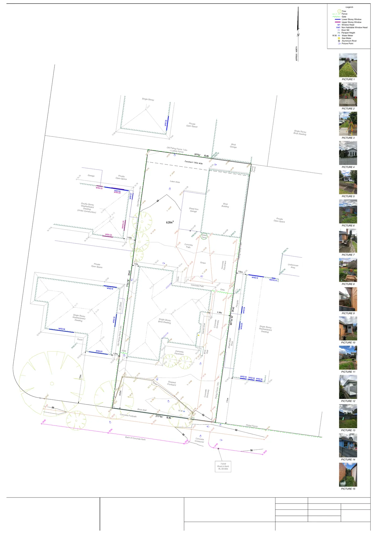
Feature survey of a 628 m² suburban lot with a single-storey brick dwelling, drawn at A1 so the block and both neighbours sit at one scale. Levels run from a temporary bench mark on a rivet in the kerb across the lawn, driveway and paths to the rear, where a sheet-iron garage, a brick outbuilding and a water tank sit beside a 1.83 m easement. Because a new dwelling was planned, the adjoining houses carry habitable and non-habitable window heads, door sills and parapet heights for overlooking and overshadowing checks, and a double-storey weatherboard under construction next door is shown as it stood. Fences are typed and heighted, trees have canopy spreads, services are picked up to the meters, and fifteen photo points are keyed to the pictures down the right margin. From the surveyor’s point file, field sketches, site photos and the plan of subdivision, we drafted the sheet with the title bearings and distances around the lot.

Location
VIC
Sector
Residential
1 sheet
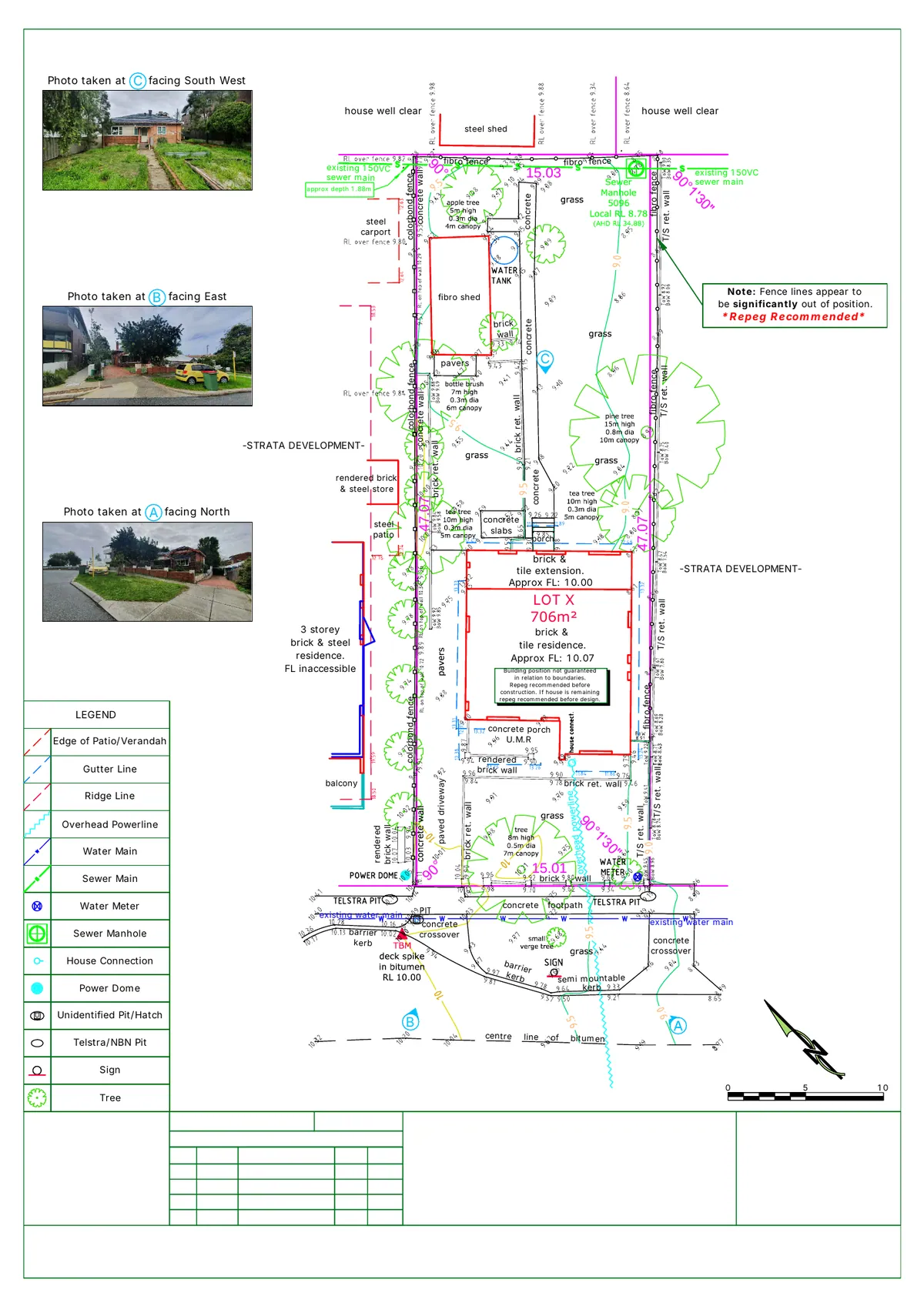
Sheet 1 of Strata Site Feature Survey, WA
SUR-02

Strata Site Feature Survey

The brief was a strata development, so this plan is built around what the designer needs before subdividing: a 706 m² lot 15.03 m wide and 47.07 m deep, with the brick-and-tile residence (floor about RL 10.07) and its tile-roofed extension, a steel carport, two sheds, a water tank and a store all positioned, and timber-sleeper and brick retaining walls stepping down both side boundaries. Levels sit on a local datum from a deck spike in the bitumen (RL 10.00) and are tied to AHD through the sewer manhole at the rear. The frontage carries the water and sewer mains, Telstra pits, a power dome and the overhead line, and three photo points are printed with their directions. The line that matters most is the surveyor’s warning: the fences appear significantly out of position, so the building position is not guaranteed and a repeg is recommended before design. We drafted the sheet from the field data, sketches and photos.

Location
WA
Sector
Residential
1 sheet
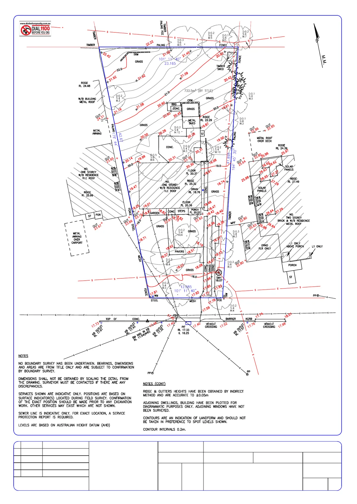
Sheet 1 of Feature & Contour Survey Plan, NSW
SUR-03

Feature & Contour Survey Plan

A contour and detail survey says as much in its notes as in its linework, and this one is honest about both. No boundary survey was done, so the bearings and dimensions are from title and the boundaries wait for confirmation; services are plotted from surface indicators only, the sewer line is indicative pending a service protection report, and the adjoining dwellings are diagrammatic with ridge and gutter heights taken indirectly to ±0.05 m. Within those limits the lot is fully described: levels on AHD from a permanent mark, contours at 0.2 m intervals showing about five metres of fall from the rear fence to the kerb, the single-storey weatherboard residence with floor and ridge levels, a metal shed, a timber retaining wall, paling fences, trees with trunk diameter, spread and height, and the neighbour’s solar panels and window heads and sills. We drafted the A4 sheet from the surveyor’s field data and sketches for a dwelling design on the slope.

Location
NSW
Sector
Residential
1 sheet
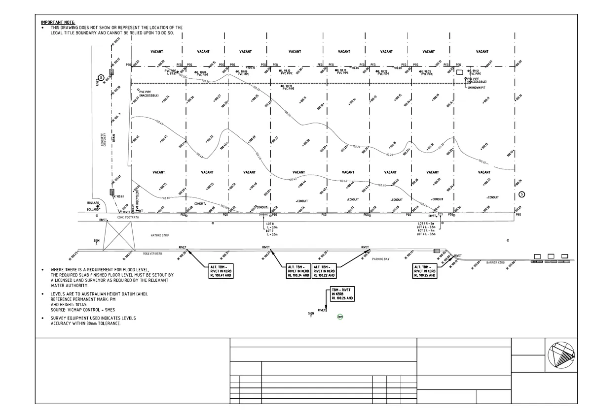
Sheet 1 of Multi-Unit Feature Survey Plan, VIC
SUR-04

Multi-Unit Feature Survey Plan

Overall feature plan at 1:250 of eight vacant townhouse lots in a new estate, surveyed before slab design. Control is on AHD from a state permanent mark, with a rivet in the kerb as the primary bench mark and four alternative rivets along the frontage, and the plan states that the equipment holds levels within 30 mm. Each lot is picked up the same way: title pegs at the corners, the stormwater stub and conduit with invert levels where the pipe was accessible, contours across the lots, and the kerb, invert, footpath and nature-strip levels along the avenue, with the lane, parking bay, bollards and pits at the ends. The notes draw the line a surveyor must draw: this is not a title re-establishment survey, the dashed boundaries are approximate, and any slab level set to a flood requirement must be set out by a licensed surveyor. We drafted the plan and legend from the field data and the estate plan of subdivision.

Location
VIC
Sector
Multi-residential
1 sheet
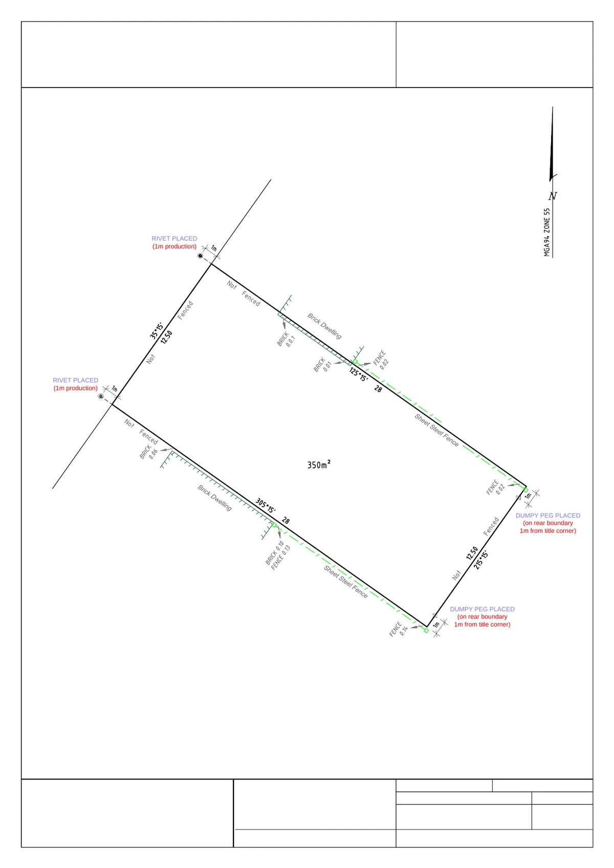
Sheet 1 of Title Re-establishment Plan, VIC
SUR-05

Title Re-establishment Plan

Title re-establishment drafting for a 350 m² lot in a new estate, prepared from a licensed surveyor’s field data rather than from a survey of our own. The surveyor fixed the four corners on MGA94 bearings over a 12.50 × 28 m rectangle; we drew the title boundaries with bearings and distances and set the occupation against them: sheet-steel side and rear fences 0.02 to 0.14 m off the line, the two neighbouring brick dwellings 0.01 to 0.14 m from the boundary, and a street frontage not yet fenced. The marks placed are shown as the builder will find them: rivets 1 m in production on the front corners and dumpy pegs on the rear boundary 1 m from the title corners. The sheet carries the licensed surveyor’s encroachment notes and certification, because a re-establishment plan is only as good as the words that bind it.

Location
VIC
Sector
Residential
1 sheet
Sheet 1 of Construction Set-out Plan, VIC
SUR-06

Construction Set-out Plan

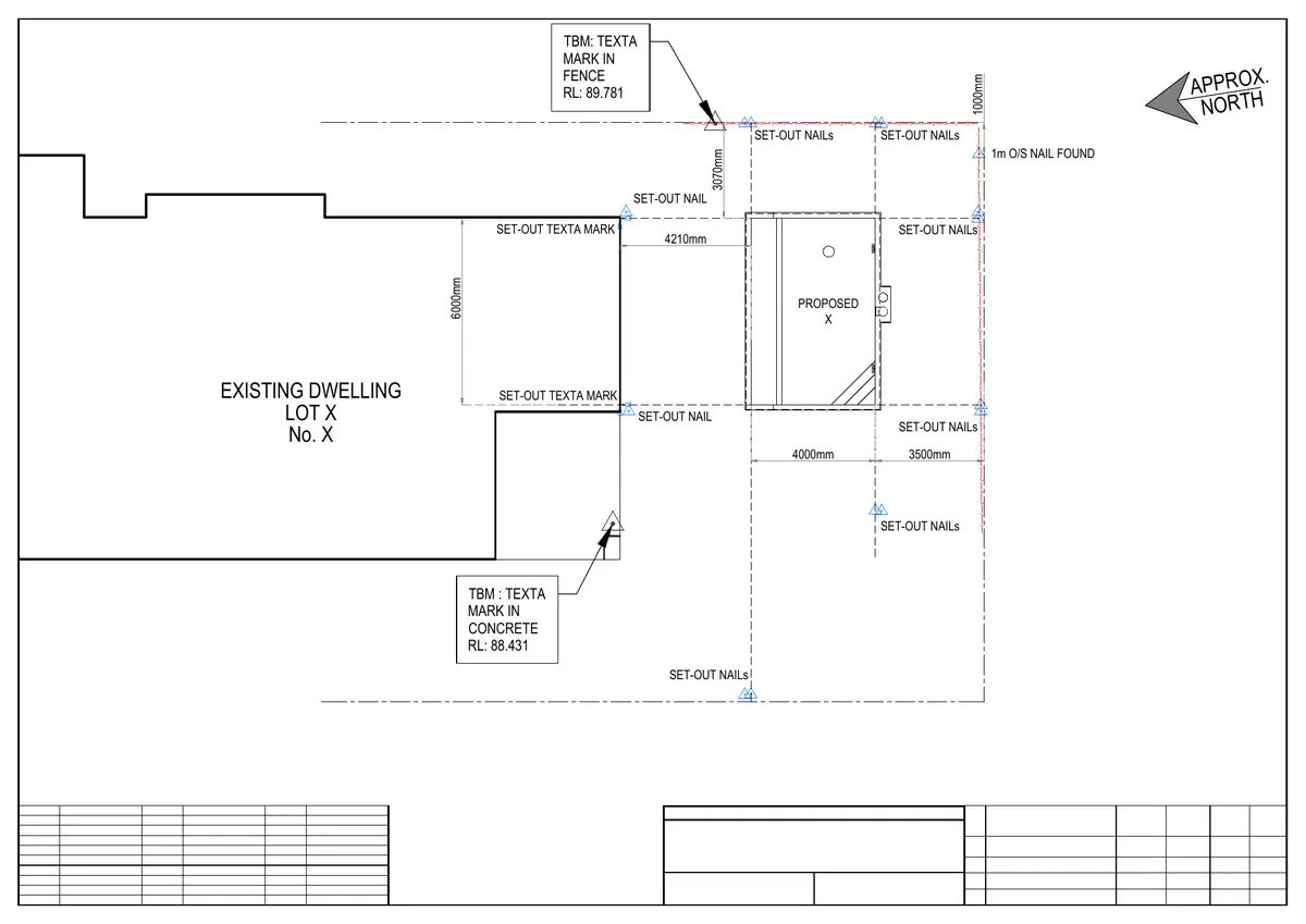
Set-out plan for a proposed structure in the rear yard of an existing dwelling, drawn at 1:100 on A3 from the surveyor’s field notes and the design drawings. The field crew placed nails on a 1 m offset line along the rear and side fences, picking up an older 1 m offset nail on the way, and texta marks on the dwelling wall, then measured the outline of the structure off them: 3070 mm from the rear offset line, 4210 mm from the house, 4000 and 3500 mm to the nails along the side. Two temporary bench marks, a texta mark in the fence (RL 89.781) and one in the concrete (RL 88.431), carry the levels on an arbitrary datum. Two notes keep the plan honest: the dimensions were formally requested and approved by the client before set-out, and nothing on the sheet shows or represents the legal title boundary. We drafted the plan and legend so the builder can check every mark on site.

Location
VIC
Sector
Residential

Need survey drafting?

Feature, level and contour drawings and site analysis, the base every later discipline builds on.